Netmap is a package that aids in the visualizations of network objects (made with the network or the igraph package) on geographical maps, imported through sf. Vertices in the network are linked with features in the sf object either directly if they share a common attribute or by an optional look-up table. The package either creates data frames that can be used in a ggplot2 plot or adds to sf features attributes like centrality indices or variables representing connections to a certain node.
You can install the development version of netmap from GitHub with:
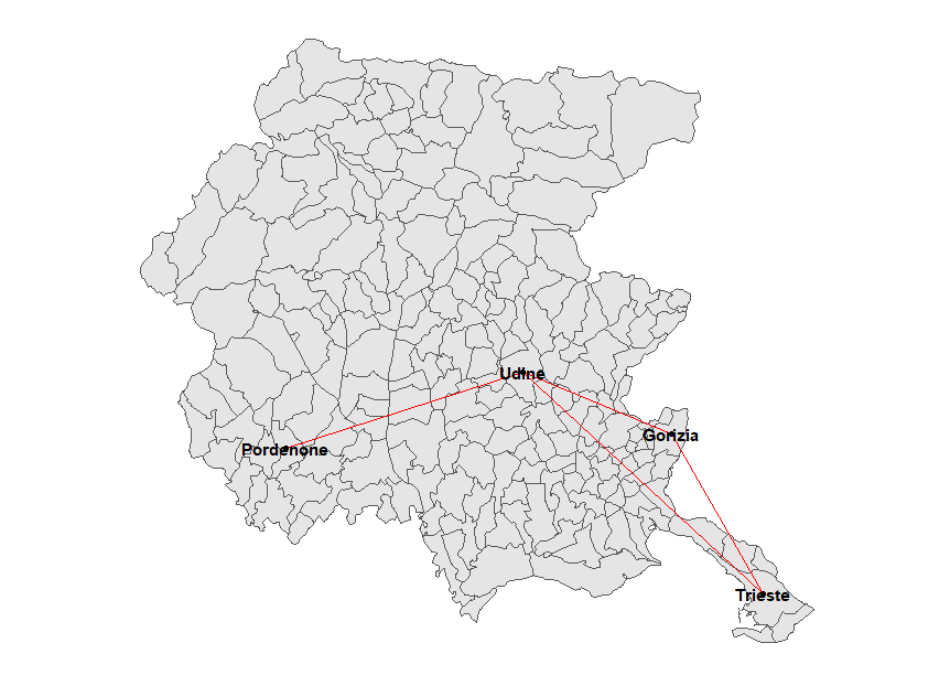
We take a network object, where each vertex is a geographical object, and overlay the network on the map. I.e. a network could represent direct bus routes between cities. We can plot the network as overlayed on the complete map or just the 4 cities in the network The Friuli Venezia Giulia region in northeastern Italy has four major cities: from east to west, Trieste, Gorizia, Udine and Pordenone. Let’s imagine that we want to plot a network with these cities as vertices and edges between Trieste and Gorizia, Gorizia and Udine, Trieste and Udine and Udine and Pordenone.
library(ggplot2)
library(netmap)
data(fvgmap)
routes=network::network(matrix(c(0, 1, 1, 0,
                                 1, 0, 1, 0,
                                 1, 1, 0, 1,
                                 0, 0, 1, 0), nrow=4, byrow=TRUE))
network::set.vertex.attribute(routes, "names", value=c("Trieste", "Gorizia", "Udine", "Pordenone"))
routes_df=netmap::ggnetmap(routes, fvgmap, m_name="Comune", n_name="names")
ggplot() +
  geom_sf(data=fvgmap) +
  ggnetwork::geom_edges(data=routes_df, aes(x=x,y=y, xend=xend, yend=yend), colour="red") +
  ggnetwork::geom_nodes(data=routes_df, aes(x=x,y=y)) +
  ggnetwork::geom_nodetext(data=routes_df, aes(x=x,y=y, label = Comune), fontface = "bold") +
  theme_blank()
It is also possible to plot a sf object with centrality measures of the network:
routes2=network::network(matrix(c(0, 1, 1, 0, 0, 1 ,
                                 1, 0, 1, 0, 0, 1,
                                 1, 1, 0, 1, 1, 1,
                                 0, 0, 1, 0, 1, 1,
                                 0, 0, 1, 1, 0, 0,
                                 1, 1, 1, 1, 0, 0), nrow=6, byrow=TRUE))
network::set.vertex.attribute(routes2, "names",
                              value=c("Trieste", "Gorizia", "Udine", "Pordenone",
                                      "Tolmezzo", "Grado"))
lkpt=data.frame(Pro_com=c(32006, 31007, 30129, 93033, 30121, 31009),
                names=c("Trieste", "Gorizia", "Udine", "Pordenone", "Tolmezzo",
                        "Grado"))
routes2_df=netmap::ggnetmap(routes2, fvgmap, lkpt, m_name="Pro_com", n_name="names")
map_centrality=netmap::ggcentrality(routes2, fvgmap, lkpt, m_name="Pro_com",
                                    n_name="names", par.deg=list(gmode="graph"))
ggplot() +
  geom_sf(data=fvgmap) +
  geom_sf(data=map_centrality, aes(fill=degree)) +
  ggnetwork::geom_edges(data=routes2_df, aes(x=x,y=y, xend=xend, yend=yend), colour="red") +
  ggnetwork::geom_nodes(data=routes2_df, aes(x=x,y=y)) +
  ggnetwork::geom_nodetext(data=routes2_df, aes(x=x,y=y, label = names), fontface = "bold", colour="") +
  theme_blank()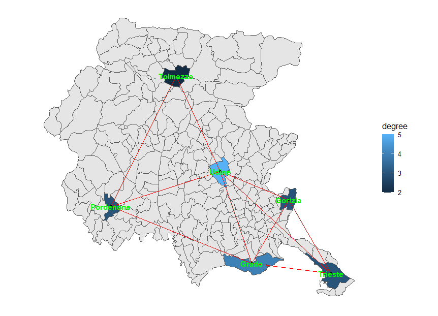
Just the network can be plotted as well without using ggplot2. For this purpose, a simple layout function, network.layout.extract_coordinates, is provided for use with plot.network or plot.igraph. A user-friendly wrapper, netmap_plot, is available.